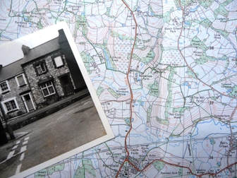
Old maps are a very important and a vital tool for tracing your house. When all else fails and the name or number is changed, or in some cases the address alters the position on a map will remain constant. The map will also show you how the town or village has altered over the years and the information you find will be a guide to the social and economic life of the community. The first place to check for maps is in the local library or record office. Several types of map survive and you need to ask your local library or record office which they have.
Ordnance SurveyFrom military beginnings Ordnance Survey has provided maps and charted the changing face of the nation for over two centuries. The fear of invasion by Napoleon led to the mapping of the whole country in detail, and is also the source of the intriguing name 'Ordnance Survey'. The earliest maps where they survive may be found in family and estate collections, in local history libraries or record offices. Tithe Maps and AwardsThe Tithe Commutation Act 1836 act allowed tithes to be paid in cash rather than goods. It became vital therefore to draw up a map and a schedule giving the names of all owners and occupiers of land in the parish. In fact some tithe owners prepared maps for their own use to show who owned what land. A powerful tool for House Historians - |
Enclosure Maps |


|
|
Goad fire Insurance Maps and Plan
Goads Fire Insurance Maps Chas E Goad Co was the largest and most prolific producer of maps which were designed to aid insurance companies to assess risks. They made large-scale plans of urban areas which ranges in size from just eight sheets for Dover and over 500 for London. These maps include footprints and addresses for each building, with its use (commercial, residential, educational etc.) and the height of the building. Construction materials were identified (and thus its risk of burning), as were special fire hazards, such as chemicals, kilns, and ovens. Information could also indicate the likelihood of large groups of people in a building, for example in schools and places of worship. The width of streets, addresses and the proximity of fire services and water supplies appear. High-risk industrial facilities such as factories and mills, warehouses, and port/transport areas were given particular attention
Goads Fire Insurance Map
Goads Fire Insurance Map
Where can i find out more?
|
Finding Maps
There are many sources for maps on line. Comprehensive historical maps archives at Old maps A magnificent collection of maps are available at http://maps.nls.uk/. Here you will find over over 48,000 maps as high-resolution, colour, zoomable images dating between 1560 and 1961. Most relate to Scotland but there is a small selection of maps of England, Ireland, Great Britain and Belgium. This resource is open access with no requirement to register. Ordnance Survey web site and Cassini maps |
|
Check the historical social class of your London street using Charles Booth’s poverty maps, compiled between 1886 and 1903
TheGenealogist has the innovative Map Explorer which adds rich functionality to its growing collection of map-based records. This powerful new tool has been developed with georeferenced historic maps overlaid over several modern background maps including
Ordnance Survey, Open Street Map and Bing satellite and hybrid road/satellite view.
The British Library has one of the largest collections of maps, plans and topographical views in the world, numbering some 4.5 million, with a chronological spread of over 2,000 years.
Layers of London is a map-based history website developed by the Institute of Historical Research. Users can access free historic maps of London and contribute stories, memories and histories to create a social history resource about their area
.
PRONI Historical Ordnance survey maps for Northern Ireland
A vision of Britain between 1801 and 2001.
Including maps, statistical trends and historical descriptions
The Bomb Sight project is mapping the London WW2 bomb census between 7/10/1940 and 06/06/1941. These allow you to explore where the bombs fell and to discover memories and photographs from the period
Baedeker Guidebooks has a collection of old maps published before 1939.
Lost Streets in London from Maps.thehunthouse
For maps of South West England go to Know Your Place It's free to use and anyone can add to the map.
Fantastic collection of old maps for sale at Alan Godfrey Maps
Modern Maps can be used to try to locate a road or village
Google Maps
A really useful site to find a parish in UK and details such as the neighbouring parishes down load Par Loc
A useful site providing a list of every village in the UK go to Anyvillage
Local History Online provides useful links to nearly 150 local history websites
Cassini produce a number of maps including Old Series Maps Click here for more details
Books
Maps and Plans for Family Historians (PRO Publications) - a guide to National Farm Survey, Valuation Survey and Tithe maps at the PRO)
Kain and Oliver's Tithe Maps and Awards - a guide to tithe maps and awards in the PRO.
Maps and Plans for Family Historians (PRO Publications) - a guide to National Farm Survey, Valuation Survey and Tithe maps at the PRO)
Kain and Oliver's Tithe Maps and Awards - a guide to tithe maps and awards in the PRO.
Helping you find locations
You should be able to find details about county, towns or parishes histories in the local library.
You should be able to find details about county, towns or parishes histories in the local library.
Surveys
The Pevsner Architectural Guides (Buildings of England, Ireland, Scotland and Wales) (Penguin Books and Yale University Press, 1951-present)
The Victoria History of the Counties of England (Institute of Historical Research, 1900-present)
The Royal Commission on the Historical Monuments of England: county inventories and thematic surveys (1912-99)
Survey of London: parish volumes and monograph series (1900-present)
Victoria County History series - a county by county history of local places
Place Name Society - investigates the origins of place names
Lewis's Topographical Dictionary
Bartholomew’s Gazetteer of Places in Great Britain